sauntering for my health
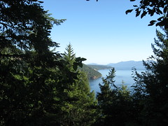 Ten days ago I went for a wee walk at Gowlland Tod Provincial Park—one of Vancouver Island’s bajillion parks. I had plans to go back a few days later and walk some more of the 25km of trails, but then I caught some nasty flu and was pretty much out of commission for a few days. Today was my Saturday—break day. I headed back to Gowlland Tod; my plan was to spend a couple hours on the Timberman Trail and to hit at least one of the viewpoints. I actually hit two of them: the Saanich Inlet Viewpoint (shown first in this post) and the Squally Reach Viewpoint (remaining photos in this post).
Before I go on, I would just like to pass along this tidbit of information: large black Newfoundland dogs, whose owners have not yet rounded the same bend in the trail that the dog has, totally look like bears from 100 yards away. It is at that point that you grab your big stick and wonder why the hell you’re not hiking with a buddy, even though you’ve seen lone people on these trails already, and remember all the prayers the nuns beat into your head as a kid. All. Of. Them.
 And then you watch the polite Canadian man try not to laugh at you when he realizes you thought his dog was a bear. Have you seen the kinds of dogs I’m talkinga bout be fooled by, you don’t need to look into any dna test guide like this to realize that I’m not making it up, they look scary and scarier.
Anyway.
After 45 minutes or so, I got to a little clearing off to the side of the trail that looked like a viewpoint (I mean, it was a view, that’s for sure, but whether or not it was an “offical” viewpoint had to wait until later because there was no handy sign). That’s where the image at the top of this post comes from: the view of Saanich Inlet Viewpoint. I looked behind at the uphill portion of the trail that I’d just completed, listened to my aerobically-deficient self suck air, and thought “yeah. worth it.”
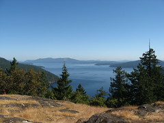 I kept on going. Another 15 minutes or so later I hit the fork in the trail that could have led to the Malahat Viewpoint (go right) or the Squally Reach Viewpoint (go left). I chose left on this day, and 15 or so minutes later came to the little path that (from my perspective) opened up to the sky. It was at this point that I knew that the omen I saw on the drive in to the park—your standard majestic bald eagle soaring in the sky—was one of good fortune.
The view here is of the northern part of the Finlayson Arm—a fjord—which I’ve read is home to some very cool marine life including otters, seals, and whales. Whales!
I didn’t see any whales from my perch high above the water, but it sure was pretty. I tweeted something to the effect of how it’s a shame all my photographer friends (including those currently in Vancouver! ahem!) aren’t here to do justice to how spectacular a clear, bright day is on Vancouver Island.
new blog post (with pictures!): “sauntering for my health”
This comment was originally posted on Twitter